
These are the reports made by highly qualified experts that confirm what we suspected. One mile north of Flathead Lake is not the place for the groundwater discharge of partially treated wastewater. Read for yourself what they had to say…
MEMORANDUM
Date: February 7, 2025
To: Mayre Flowers, Citizens for a Better Flathead
From: David A. Donohue, M.S., P.G., Senior Hydrogeologist, HydroSolutions Inc
Subject: Hydrogeologic Review Comments on Permit Fact Sheet, Montana Ground Water Pollution Control System (MGWPCS), Lakeside County Water and Sewer District, Permit Number MTX000307, Flathead County, Montana
On behalf of Citizens for a Better Flathead, I completed a review of the hydrogeologic, and environmental resource information presented in the Permit Fact Sheet, Montana Ground Water Pollution Control System (MGWPCS), Lakeside County Water and Sewer District, Permit Number MTX000307, Flathead County, Montana. My review focused on assessment of the thoroughness of the site characterization presented by the applicant, collection, analysis, and interpretation of appropriate data for the site, and suitability of the shallow groundwater system to receive infiltration of a large volume of wastewater from three rapid infiltration basins (RIBs).
In general, the Fact Sheet evaluates the shallow hydrogeologic environment with baseline data that is significantly lacking in detail. The data collected neglects the complexity of the shallow deltaic sand aquifer (Delta aquifer) with multiple preferential pathways, ignores the impact of undefined temporal and spatial contaminant transport pathways, and neglects the potential to degrade human health and the environment now and in the future.
It is entirely inadequate for the applicant to have relied on only five monitoring wells to characterize the hydrogeology of the complex heterogeneous Delta aquifer over 163 acres of the permit area. Proposing to characterize the hydraulic conductivity from slug tests from the five monitoring wells is a serious flaw in the design plan and hardly provides defensible data. Pumping tests are neglected. Averaging hydraulic conductivity from slug tests from two orders of magnitude difference is ineffective in characterizing preferential flow pathways in the Delta aquifer.
The Fact Sheet lacks specific details on how the release of wastewater contaminants will be managed when the multiple and complex transport pathways are not defined. There is no plan of action to stop discharge of wastewater into the shallow aquifer when nutrient concentrations exceed permit standards outside the mixing zone and threatening downgradient domestic water sources. Information presented by the applicant does not provide sufficient information on how shallow groundwater resources used by local residents with senior water rights as well as recharge to wetlands, ponds, Ashley Creek, the Flathead River, and Flathead Lake will be protected. The Delta aquifer feeds groundwater into surface water bodies and transport of contaminants into surface water cannot be ignored.
The publicly available data accompanying the draft permit is inadequate to form a defensible scientific basis for characterizing the receiving aquifer or its ability to transport wastewater pollutants off-site. Further, the lack of any meaningful monitoring or mitigation plans capable of assessing permit compliance based on changes in the receiving aquifer or downgradient surface water quality is also scientifically indefensible. INFORMATION REVIEWED At this time, the primary sources of information that I have reviewed and used as the basis for my comments and opinions are as follows: • Permit Fact Sheet, Montana Ground Water Pollution Control System (MGWPCS), Lakeside County Water and Sewer District, Permit Number MTX000307, Flathead County, Montana. • Report of Geotechnical Investigation, Lakeside Wastewater Project, Alpine Geotechnical. May 20, 2022 • MBMG Ground Water Information Center (GWIC) database of water wells.
FACT SHEET REVIEW COMMENTS
General Comments
1) The initial methodology, approach, and data collected to characterize the hydrogeologic environment impacted by the rapid infiltration system (RIS) are flawed and require a through reevaluation.
2)The applicant completely oversimplified the hydrogeologic conditions associated with the shallow aquifer when evaluating hydraulic conductivities, contaminant travel times, fate and transport modeling, and pathogen movement. The hydrogeologic data were oversimplified and inaccurately used to analyze all aspects of the RIS plan. Many conclusions are based on limited and incorrect data.
3) The hydrogeologic environment where the RIS is located is reported in numerous hydrogeologic studies as a deltaic sedimentary deposit. The complexity of the flow system is controlled by highly transmissive preferential flow paths, low transmissive over bank or low velocity deposits, and variable grain size distribution across the deltaic depositional environment. The coarser-grained deposits are generally found in the distributary channels and the finer-grained deposits are found further away from the channels. This complex hydrogeologic environment presents an extreme challenge to confirm groundwater flow and pathway of travel that will control the movement of discharged wastewater from the RIBs into the shallow groundwater system, a critical source of clean groundwater that cannot be ignored.
4) Either the RIS system should be relocated to a more favorable hydrogeologic location where the probability of offsite contaminant transport to surface waters does not exist, eliminated altogether, or a more sophisticated and detailed drilling, shallow geophysical, and hydrogeologic investigation should be undertaken to understand how groundwater flow in the underlying shallow aquifer is currently moving and will be moving under the proposed 200,000 gpd load. This detailed investigation is needed to support the applicant’s conclusion that fate and transport in the Delta aquifer is fully understood, and the inflow of wastewater load will not impact groundwater and surface water resources.
5) This complex hydrogeologic environment presents a challenge to confirm groundwater fate and transport that will control the movement of discharged wastewater from the RIBs into the shallow groundwater system. The shallow groundwater system is a critical source of clean groundwater that must be protected, especially given the receiving aquifer's hydrologic connectivity to downgradient surface waters including Wiley’s Slough, Ashley Creek, adjacent ponds and Flathead Lake.
6)A common approach to evaluating shallow hydrogeologic conditions in such complex environments is to install multiple wells on an established grid pattern, and complete shallow geophysical surveys to identify preferential pathways. Applicants’ evaluation clearly fails to present an accurate and defensible representation of the hydrogeologic system for use in making informed and defensible permitting decisions.
The following specific comments address key issues and concerns from the Fact Sheet and are identified by page and section from the Fact Sheet.
Specific Comments
Comment 1. Page 12. Section 2.3. Figure 6B is identified as a hydrogeologic cross section of the lower Flathead Valley from LaFave 2004. However, the cross-section line is located 10 to 15 miles north of the proposed RIS property and deltaic deposits. More representative and multiple cross sections of the hydrogeologic units located at the RIS property must be prepared, based on on-site borehole data, to better understand the complex shallow groundwater conditions. The importance of having more accurately located monitoring wells and boreholes across the permit boundary cannot be emphasized enough. Also note that the aquifer materials identified on Figure 6B cross section include sand and gravel for the shallow, intermediate, and deep alluvium. This lithology does not line up with the lithologic descriptions in monitoring wells MW 1 through MW5 located in the Delta aquifer.
Comment 2. Page 12. Section 2.3. Paragraph 3. The text in this paragraph confirms the complexity of the shallow groundwater flow paths and hydrogeologic conditions that have not been investigated thoroughly in order to clearly understand how wastewater will impact the shallow groundwater, surface water, and Flathead Lake. This is a fatal flaw with approving the RIS at this location.
Comment 3. Page 12. Section 2.3. Paragraph 4. It is inaccurate to base the hydrogeologic investigation, data analysis, and conclusion on results from only five monitoring wells and average slug test data completed at the RIS property. The property extends across approximately 163 acres. The text states that the lithology is the same poorly graded silty sand in the five monitoring wells; however, the slug tests completed in the wells indicate a wide variation in hydraulic conductivity values calculated from the “silty sands.” The hydraulic conductivity (K) calculated in the five wells varies over two orders of magnitude, with an estimated low of 6.7 feet per day to a high of 490.5 feet per day. The higher conductivity values may represent the conductivity of the 10-20 silica sand filter pack and not the aquifer material adjacent to the borehole. The higher value may also represent a highly transmissive preferential flow path. The reason for such variability in the calculated hydraulic conductivity cannot be ignored and must be further investigated. It is also possible that the hydraulic conductivity value of 490.5 feet per day may not be the highest value within the permit boundary. Published scientific literature supports the heterogeneous nature, preferential pathways, and varying hydraulic conductivity values found within the receiving Delta aquifer.
Comment 4. Page 15. Section 2.4. Paragraph 2-4. The applicant uses a 38-year-old, 1986 report with the intent to support their conclusion that the flow paths in the shallow Delta aquifer have not changed. The Noble and Stanford (1986) report based their conclusions on hydrogeologic conditions that are now nearly 40 years dated. It is obvious that a defensible hydrogeologic investigation of a wastewater infrastructure project of the scale as the proposed RIS requires extensive site-specific testing and analysis of the receiving aquifer to support conclusions regarding contaminant fate and transport. Additionally, the applicant’s data collected from five widely spaced, two-inch diameter monitoring wells installed in large diameter boreholes and backfilled with 10-20 silica sand filter pack does not likely represent site hydrogeologic conditions. Much more evaluation of the shallow Delta aquifer, installation of more borings and monitoring wells, and additional testing and modeling must be completed before a viable and informed permitting decision can be made.
Comment 5. Page 18. Section 2.5. The first sentence of Section 2.5 states:
“Given the complexities of ground water flow in the area, it was important to collect a thorough suite of site specific hydrogeologic data to develop this permit.”
Although I agree with the goal as stated, the investigation and associated data, analysis, and conclusions fell short of the goal and did not provide defensible evidence to support approval of this permit for the following reasons:
1) Five monitoring wells are insufficient to evaluate the hydrogeologic conditions beneath the permit boundary, let alone the specific hydrogeologic conditions outside of the permit boundary. The heterogeneous and anisotropic aquifer across 163 acres cannot begin to be characterized with data from only 5 monitoring wells.
2) Fifteen slug tests were completed in 5 monitoring wells and identified a significant range of hydraulic conductivity (K) values among the 5 locations and three slug tests per well. Calculating an average K from the results of 3 slug tests on 5 wells, then averaging the results of the 5 averages to derive at an average K for the entire 163-acre site is not a reasonable approach to characterizing the heterogeneous Delta aquifer. The applicant must complete a more thorough and comprehensive baseline investigation. Description and development of a site-specific hydrogeologic conceptual model would be an important first step to help focus the study.
3) The information provided in Paragraph 3 is incorrect. Monitoring wells do not all have a 10-foot screen length. According to monitoring well boring and construction logs, MW1 and MW2 have 10-foot screens, MW3 has a 14-foot screen, and MW4 and MW5 are completed with 20-foot screens. Saturated thicknesses ranged from 12.79 to 19.53 feet.
4) Applicant should check that correct aquifer parameters were used in their slug test analyses, calculations, and presentation of estimated transmissivity values since they may affect results. In addition, please explain why depth to water (DTW) measurement is listed as NM on MW5 boring and well construction log. The applicant needs to address the fact that the shallow groundwater table will fluctuate seasonally as a result of runoff, rainfall, and recharge events.
5) Note that transmissivity values in Paragraph 3 appear to be listed incorrectly, such as 1,2240 ft2/day, and 1-3,700 ft2/day. Is a transmissivity value of 1 ft2/day actually present? Please correct the presentation of transmissivity calculations.
6) Ambient nitrate-nitrite samples were collected from only monitoring well MW5. Samples must be collected from all five monitoring wells and selected private wells so that a more extensive spatial representation of ambient nitrate-nitrite concentrations in the shallow aquifer can be assessed and included in fate and transport discussion.
Comment 6. Page 20. Figure 9. Figure 9 represents groundwater flow maps from the facility’s five monitoring wells. These wells summarize 11 months of groundwater flow in a small area. The applicant neglected to consider preferential flow paths both within the southern part of the permit area and outside of the permit area within the Delta aquifer. This oversight must be corrected, and groundwater investigation within the southern permit area, which includes RIB-3, must be included.
Comment 7. Page 35. Section 3.1. The permit application must explain how mitigation will address breakthrough and impacts to surrounding domestic wells and surface water bodies.
Comment 8. Page 3. WET Technical Memorandum The text incorrectly states that “individual hydraulic conductivity estimated from slug tests ranged from 7.1 ft/day to 392.4 ft/day (Table 1). Those values represent the average of three slug tests in each of the five wells. The correct individual hydraulic conductivity estimated from slug tests ranged from 6.7 ft/day to 490.5 ft/day. This discrepancy needs to be corrected. In addition, the average hydraulic conductivity value of 122.4 ft/day is significantly less than the highest calculated value of 490.5 ft/day. This difference must be addressed in your baseline site characterization evaluation.
Comment 9. Page 4. WET Technical Memorandum. Assumptions based on insufficient data and analysis from monitoring wells, slug tests, and associated conclusions are not accurate to address the complexity of the shallow Delta aquifer. The aquifer characteristics presented in Table 2 need to be reevaluated. Field verification of all wells at or near the 500-foot setback requirement must be completed. GWIC location are not always accurate and may indicate wells that are outside the setback distance but are actually inside the setback zone as well. Please explain what the “further research” used to confirm that the three wells are outside the 500-foot setback?
Comment 10. Page 10. WET Technical Memorandum The K values calculated from slug test results include 2 orders of magnitude difference. These results are consistent with the complexity of the shallow aquifer and the uncertainty associated with results obtained from the slug tests. The applicant has not satisfied the requirement to complete a thorough hydrogeologic assessment and analysis of impacts resulting from the proposed wastewater discharge. It is often considered that slug tests cannot be a replacement for pumping tests since slug tests only allow for evaluating a small volume of aquifer material surrounding the borehole (Kruseman and deRidder 1991). Disturbance of the borehole wall and placement of transmissive filter pack will have an effect on water movement into and out of the aquifer.
A thorough geologic assessment of the hydrogeologic environment must be completed and must include more boreholes, more wells, and pumping tests. Additionally, in order for the slug test results to be independently verified, the applicant must provide the raw data in electronic format that was used in all slug test analysis. Also, please provide details and documentation on the slug test and describe the equipment and methods.
The Bouwer and Rice slug test solution for unconfined aquifers was used to analyze slug test data. The Bouwer-Rice solution described in Duffield (2007) has the following assumptions:
aquifer has infinite areal extent.
aquifer is homogeneous and of uniform thickness.
aquifer potentiometric surface is initially horizontal.
control well is fully or partially penetrating.
a volume of water, V, is injected or discharged instantaneously from the control well.
aquifer is confined or unconfined.
flow is steady.
It is apparent from the baseline data that the assumptions listed in bullets 1, 2, and 3 are not met. The applicant must explain how failing to meet these assumptions impacts the estimated hydraulic conductivity results.
Comment 11. Page 5. WET Technical Memorandum The applicant states that groundwater flow into or from Flathead Lake is controlled by the stage of Flathead Lake. Given that the area will likely experience lower water levels in Flathead Lake due to climatic changes and increased drought conditions, the applicant should expect groundwater to flow more often into the lake. The fate and transport models should be run to account for this additional loading into surface waters and Flathead Lake.
Comment 12. Page 6. Paragraph 1. As documented in earlier comments, slug tests only represent hydraulic properties located immediately around the borehole. The order of magnitude differences calculated from slug test results points to the complexity of the hydrogeologic environment. An average K value, carried through the characterization and modeling in the permit is not justified and needs to be reevaluated.
REFERENCES
Duffield, G.M., 2007. AQTESOLV for Windows Version 4.5 User's Guide, HydroSOLVE, Inc., Reston, VA.
Kruseman, G.P. and deRidder, N.A. 1991. Analysis and Evaluation of Pumping Test Data. Second Edition. International Institute for Land Reclamation and Improvement. Publication 47.
LaFave, J.I., Smith, L.N., Patton, T.W., 2004, Ground-water resources of selected shallow aquifers in the north Flathead Valley and Flathead Lake perimeter, northwest Montana, Montana Bureau of Mines and Geology: Ground-water Assessment Atlas 2A, 132 p.
Noble. R.A., and Stanford, J.A. 1986. Groundwater Resources and Water Quality of the Unconfined Aquifers in the Kalispell Valley, Montana. Flathead Lake Biological Station Report 093-86.

MEMORANDUM
Date: February 7, 2025
To: Mayre Flowers, Citizens for a Better Flathead
From: Michael T. Meredith P.G., Hydrogeologist, HydroSolutions Inc Hydrogeologic
Subject: Review Comments on Mounding Model submitted by Lakeside County Water and Sewer District for Montana Ground Water Pollution Control System Permit Number MTX000307, Flathead County, Montana
INTRODUCTION The Montana Department of Environmental Quality has issued a Fact Sheet for a Montana Ground Water Pollution Control System Permit application (MTX000307) submitted by Lakeside County Water and Sewer District (Applicant). If approved, Applicant will construct and operate rapid infiltration basins (RIBs) that will be used to dispose of domestic-in-nature wastewater to shallow groundwater north of Lakeside, Montana. I completed a review of the methodology used by Applicant for evaluating groundwater mounding below the proposed RIBs. My comments and opinions from this review are presented in this memorandum. I may update and revise these comments and opinions if additional information becomes available.
SCOPE AND INFORMATION REVIEWED My review is limited to Applicant’s groundwater mounding analysis and its implications. Documents that I based my review on are (1) Permit Fact Sheet for Permit Number MTX000307 (Fact Sheet) and (2) Appendix A of the Fact Sheet, WET Technical Memorandum (2024) (WET Memo). Additionally, I have reviewed other expert comments and opinions on Permit Number MTX000307 including (1) a Hydrologic Review Comments memorandum prepared by David Donohue of HydroSolutions Inc (Donohue Memo) and (2) a draft Expert Opinion prepared by Hauer Environmental (Hauer Opinion).
IMPORTANCE OF MOUNDING ANALYSIS The primary output of Applicant’s mounding model is calculated water table rise (mounding) due to the addition of wastewater effluent to the receiving aquifer. The amount and areal distribution of water table rise (height and shape of groundwater mound) is a critical element of the Permit because it both directly (through mound height) and indirectly (via calculated hydraulic gradients) influences contaminant fate and transport calculations and models that are being used to justify the Permit, including:
Calculation of groundwater seepage velocity and denitrification (e.g. Fact Sheet p. 32, 38; Wet Memo p. 10),
Time of travel/capture zone calculation (Wet Memo Attachment H),
DEQ pathogen transport model (Wet Memo Attachment H), and
DEQ phosphorous breakthrough analysis (Wet Memo Attachment K).
SELECTED MODEL INAPPROPRIATE FOR SITE It is my opinion that Applicant has utilized a model that is too simplistic to adequately account for the hydrogeologic complexity of the RIB site. Specifically, Applicant utilized the analytical groundwater mounding solution of Zlotnik et al. (2017), as implemented by MOUNDSOLV software (Fact Sheet, p. 25) to estimate the magnitude and extent of groundwater mounding that may occur beneath the proposed RIBs. Assumptions that underlie the Zlotnik et al. (2017) model include:
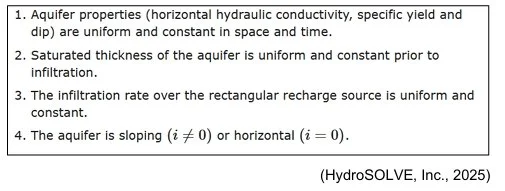
Notably, the Zlotnik model assumes that the aquifer has uniform physical properties throughout space and time (assumption #1), in effect requiring that the aquifer have the same physical properties in all directions over an infinite distance (an infinite homogenous aquifer). This assumption is not met when an aquifer has a variable (heterogenous) composition because variations in composition are associated with variations in critical model parameters such as hydraulic conductivity and specific yield.
Ultimately, when model assumptions are not met, model-calculated results tend to diverge from actual observed groundwater conditions, the magnitude of the divergence depending on the degree to which assumptions are not met. In practice, a real-world groundwater mound in a non-uniform aquifer is likely to have an irregular shape and variable distribution of groundwater head (mound height) compared to the shape and head distribution of a mound in an infinite homogenous aquifer (as calculated by Applicant’s model).
Based on my review of the Donohue Memo and the Hauer Opinion, I understand that the Delta aquifer (which will receive RIB discharge) is likely to be highly heterogenous in nature and thus does not meet the uniformity assumption of the Zlotnik model. Therefore, Applicant’s mounding model results are not likely to accurately reflect the shape and magnitude of groundwater mounding resulting from RIB operation.
Many of the contaminant fate and transport analyses used by Applicant and DEQ to demonstrate compliance with permit standards are predicated in some way on an accurate forecast of groundwater mounding conditions beneath the RIBs. However, as noted above, the basic assumption of a homogenous aquifer, which is required for Applicant’s model to accurately forecast groundwater mounding, does not appear to be met at the RIB site (see Donohue Memo and Hauer Opinion). Thus, DEQ and Applicant’s basis for meeting water quality permitting standards appears to be fundamentally flawed because it is reliant on an unreliable and potentially inaccurate analysis of groundwater mounding.
Applicant should be required to complete a revised mounding analysis utilizing a calibrated numerical groundwater model that accounts for local hydrogeologic complexity. Groundwater mounding conditions and gradients, forecast by the numerical model, should then be utilized in a re-analysis of contaminant fate and transport from the RIB site and compared to relevant permitting standards. I also note that the Fact Sheet (p. 25) erroneously implies that the mounding analysis utilized the Zlotnick model in steady state mode when in fact it was run in transient mode.
ARBITRARY MODEL PERIOD The mounding model was run to calculate mounding after 5 years of RIB operation (Fact Sheet p. 26). The duration over which the model is run is an important input parameter because it is likely to affect the height of the model-calculated mound and the groundwater gradients flowing from the mound. The Fact Sheet states the following as rationale for running the model at a time of 5 years:
A forward solution was performed for five years, at which time, due to the constant head boundary of the Flathead River and Flathead Lake, the system is believed to achieve stabilized conditions (Fact Sheet p. 26, from WET Memo p. 6).
It is my opinion that this timeframe is arbitrary and is entirely unsupported by the application materials that I have reviewed. The wording of the WET Memo itself (“…is believed to achieve…”) suggests that even its authors have low confidence in their assertion that 5 years is an appropriate modeling timeframe. Therefore, applicant should provide:
Data and references to support their assertions that Flathead Lake and the Flathead River act as constant head boundaries with respect to RIB mounding,
The detailed methodology and calculations that were used to determine that these boundaries influence RIB mounding at a time of exactly 5 years, and
Justification for why modeling mounding over a short 5-year timeframe is more appropriate than modeling mounding over the design life of the project.
Additionally, if the stated hydrogeologic boundaries do exist, they would represent yet another complexity in the local hydrogeologic environment that MOUNDSOLV and the Zlotnik model are ill-suited to handle, thus providing additional basis for use of a more capable numerical model.
SUMMARY The following is a summary of my comments and opinions:
• The mounding model results are fundamental to the Permit application because they directly or indirectly affect numerous contaminant fate and transport-related calculations central to the Permit including groundwater seepage velocity, denitrification, time of travel, pathogen transport, and phosphorous breakthrough.
• The Donohue Memo and the Hauer Opinion indicate that the Delta aquifer is likely to be highly heterogenous, which violates a fundamental assumption underpinning application of the Zoltnik groundwater mounding model utilized by Applicant. For this reason, Applicant’s mound modeling approach is considered inadequate for the hydrogeologic setting of the RIBs.
• The inadequacy of the mounding model undercuts the credibility of many contaminant fate and transport calculations, which depend in part on groundwater mounding conditions. Therefore, Applicant should be required to reevaluate mounding using a calibrated numerical groundwater model that accounts for the heterogenous nature of the receiving aquifer. Output from the numerical mounding model should be used to re analyze contaminant fate and transport with respect to permitting criteria.
• The Fact Sheet (p. 25) erroneously implies that the mounding model was run as a steady state solution when in fact the model was run in transient mode.
• The period over which the mounding model is run is important because it is likely to affect model-calculated mound height and resulting hydraulic gradients; however, Applicant has arbitrarily limited the model period to 5 years. Applicant suggests without providing evidence that hydrogeologic boundaries exist that constrain the appropriate model timeframe to 5 years. Applicant should provide evidence for the presence of these boundaries and provide the methods and calculations used to justify the 5-year model period.
• If the aforementioned boundary conditions do exist, they would represent an additional complexity that cannot be accounted for by Applicant’s chosen mounding model, underscoring the inadequacy of Applicant’s modeling and further supporting use of a numerical modeling approach.
REFERENCES
HydroSOLVE, Inc. (2025). MOUNDSOLV. Retrieved February 5, 2025, from Solutions: MOUNDSOLV Version 4 Help: http://www.aqtesolv.com/help/moundsolv/4/solutions.htm#
Zlotnik Zlotnik, V. A., Kacimov, A., & Al-Maktoumi, A. (2017). Estimating groundwater mounding in sloping aquifers for managed aquifer recharge. Groundwater, 797-810.
SIGNATURE The comments and opinions herein were prepared by Michael T. Meredith, P.G., Hydrogeologist at HydroSolutions Inc.
Michael T. Meredith, P.G. Hydrogeologist HydroSolutions Inc
2912 7th Ave N Billings, Montana 59101

February 10, 2025
Public Response: Lakeside County Water & Sewer Permit: MTX000307
F. Richard Hauer, PhD Hauer Environmental LLC
Andrew Hauer, MS Hauer Environmental LLC
The following document is the expert opinion of Hauer Environmental LLC in response to our findings of fact and judgment concerning the ecological impacts of increased nitrogen and phosphorus to nearby surface waters and to the Flathead River and Flathead Lake related to the proposed draft permit for a new Montana Ground Water Pollution Control System (MGWPCS) Domestic Wastewater Treatment and Rapid Infiltration System to service the Lakeside County Water & Sewer District (LCWSD), permit #MTX000307, Flathead County, Montana.
Background
The Montana Department of Environmental Quality (MDEQ) recently completed an Environmental Assessment and issued a draft permit for a new Montana Ground Water Pollution Control System (MGWPCS) Domestic Wastewater Treatment and Rapid Infiltration System to service the Lakeside County Water & Sewer District (LCWSD), permit #MTX000307. The proposed project provides sewage disposal in the form of a new Septage Unloading and Pre-Screening Facility and Rapid Infiltration System for the town of Lakeside, Montana and surrounding area residents (Montana Department of Environmental Quality, 2024). The MDEQ determined that the discharge of nitrogen (N) and phosphorus (P) in the e luent from the proposed rapid infiltration system would result in nonsignificant changes in water quality, per 75-5-301 (5)(d), Montana Code Annotated. The MDEQ, therefore determined that there are no significant adverse impacts associated with the Proposed Project.
The applicant proposes to build and operate a wastewater treatment plant. The wastewater generated by the county will undergo treatment and on-site disposal. Wastewater treatment may include use of advanced treatment levels with sequencing batch reactor technology with biochemical nutrient reduction (or similar). DEQ recognizes that in comparison to conventional septic treatment, the proposed treatment system provides a higher level of treatment for nutrients.
The proposed facility will use rapid infiltration basins (Outfalls 001, 002, and 003) to discharge treated wastewater to underlying groundwater. The facility’s proposed location is: Township 27N, Range 21W, Section 11N; Flathead County; Latitude: 48.1127610º North, Longitude: -114.225111º West. (Montana Department of Environmental Quality, 2024)
Proposed Sewer District Project and Wastewater Treatment - Lakeside County Water and Sewer District (LCWSD), formed in 1988, provides sewage disposal for the town of Lakeside, Montana, and surrounding area residents. The draft permit reports the collection system is currently a 100% sanitary sewer. Further, the LCWSD serves a population of 1860, 810 households, and 18 business connections (Montana DEQ #MTX000307 Fact Sheet).
The proposed project provides a new facility to accept sewage disposal for existing disposal users as well as expanded capacity to accept Septic Tank Septage from the dispersed septic systems in Flathead County. The new Septage Unloading and Pre-Screening Facility and Rapid Infiltration System, as proposed, will increase the daily flow of wastewater from the facility at an estimated rate of 200,000 gpd (Montana Department of Environmental Quality, 2024). The additional 200,000 gpd of wastewater, as proposed, would be disposed of into Rapid Infiltration Basins (RIBs); RIB1 80,000 gpd, RIB2 60,000 gpd, and RIB3 60,000 gpd. The RIBs would allow wastewater to be “rapidly” infiltrated into the porous sands underlying each RIB to be dispersed above and into the groundwater aquifer underlying the facility (see Figure 4B above and Figures 5 and 10 in the Montana DEQ #MTX000307 Fact Sheet).
The Montana DEQ Permit #MTX000307 has proposed that the discharge of nitrogen (N) and phosphorus (P) in the effluent from the Proposed Project’s Rapid Infiltration System would result in nonsignificant changes in water quality, (per 75-5-301 (5)(d), Montana Code Annotated).
In response, Hauer Environmental LLC, is providing in the context of Public Comment a review of the peer-reviewed literature, public record, and analyses of the proposed project permitted by MDEQ; specifically in response to the use of rapid infiltration basins (Outfalls 001, 002, and 003) as an effective means to discharge treated wastewater. This review document describes (a) evidence of hydrological connectivity between the receiving groundwater and the downgradient Flathead River and Flathead Lake, (b) the fate and transport of both N and P as limited nutrients in the downgradient Flathead River and Flathead Lake, and (c) the risk and uncertainties to surface water quality and ecological response.
Project Site Geology and Sedimentology
Geological Setting and Post-glacial Flathead Valley – The Flathead Valley lies at the south end of the Rocky Mountain Trench with basement bedrock composed of the Belt Supergroup. This Belt rock defines the valley-fill which is composed of glacial, fluvial, and lacustrine sediments deposited through the Tertiary and Quaternary periods. The Flathead River has played, and continues to play, an integral role in the transport and deposition of sediments north of Flathead Lake (Rose, 2018). In the headwaters of the Flathead River System the Belt bedrock consists of metasedimentary rock approximately 1.4 to 1.5 billion years in age. These pre-Cambrian mudstones contribute low concentrations of ions to solution of ground- and surface waters (Hauer F. R., Stanford, Lorang, Ellis, & Craft, 2007).
The Flathead Valley received multiple glacial advances during the late Pleistocene. The Pinedale glacial advance was the last major expansion of ice that occurred in the Rocky Mountains, including the Flathead Valley, between 30,000 and 10,000 years ago (Rose, 2018). This last advance of the Pleistocene ice sheet deposited the moraine at the south end of Flathead Lake at Polson and shaped the contemporary topography and river drainage patterns of the Flathead River System above Flathead Lake that are primarily composed of post-glacial outwash and moraine deposits. As ice melted and glaciers withdrew from the Flathead Valley, discharge of water from the melting main-lobe glacier of the Rocky Mountain Trench and the montane glaciers of the North, Middle and South Forks of the Flathead River created a highly braided network of channels in the surficial deposits of the northern half of the Flathead Valley.
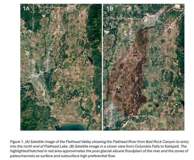
The shallow aquifer of the north Flathead Valley sits on an impermeable clay formation and is generally charged at the north end of the valley beginning down-river of the confining reach of Bad Rock Canyon and along the valley floor south of the Whitefish Range (Figure 1). Between the extant Flathead River and the Stillwater and Whitefish Rivers that flow along the west side of the upper Flathead Valley, the valley floor deposits were subjected to expansive channel braiding and sorting of cobbles and gravel (Stanford & Ward, 1988). Via high hydrogeologic interaction between the aquifer and the river, the aquifer discharges in progressively greater volumes into the river channel, spring brooks, ponds, oxbows and other alluvial channels of the paleo- and contemporary floodplain as it is constrained by the finer deltaic sediments at the south end of the valley. Today, in the northern half of the Flathead Valley, the Flathead River remains an expansive network of alluvial-sorted paleochannels hydrologically connected to the main channel extending kilometers in width and 10-20m in depth. The complex lattice of surface and subsurface features of the north Flathead Valley possess high hydraulic conductivity, preferential flow pathways that have been extensively investigated as ecological systems for over 50 yrs (e.g., Stanford & Gaufin, 1974; Hauer & Stanford, 1982; Stanford and Hauer, 1992; Stanford & Ward, 1988; Stanford et al., 1997; Tappenbeck & Ellis, 2011). The interaction between the shallow aquifer and the river is so great that invertebrates from the river have been documented traveling through the interstitial spaces of the aquifer up to 2 kilometers laterally from the river.
During the rapid glacial-melt period of high discharge in the late Pleistocene and early Holocene that created the expansive network of alluvial-sorted paleochannels, Flathead Lake extended as a lacustrine water body north of the current lake’s north shore to the vicinity of the valley near and east of Kalispell. The cobble, gravel and course-sand alluvial deposits of the northern Flathead Valley are abruptly replaced by deltaic deposits of sand and silts beginning at the break in river slope near the city of Kalispell and continuing south and extending across the valley to the contemporary north shore of Flathead Lake (Figure 2)

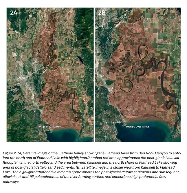
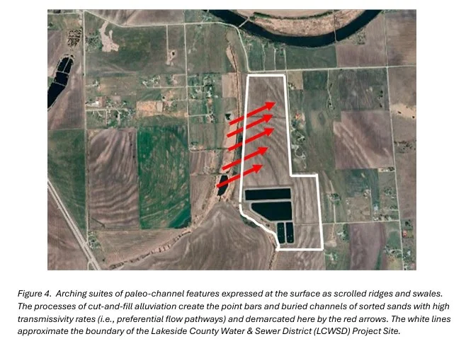
The surficial deposits of the southern half of the valley form an approximately 10-15m thick layer of sand and silt overlaying a more tightly compacted clay/silt/fine-sand layer. These surficial sands, that were initially formed as subaqueous deltaic sand deposits were subsequently subjected to extensive cut-and-fill alluviation (Lorang & Hauer, 2017) by the Flathead River after the glacial-melt period as the early Holocene ended and Flathead Lake established its contemporary lake level. Following this glacial-melt period, the Flathead River tortuously meandered through the deltaic sand deposits creating a complex suite of oxbow lakes and scrolled ridges and swales (see Figure 3) before establishing its current channel following the Creston Fault from west to east and then the Flathead (Mission) Fault south into Flathead Lake.
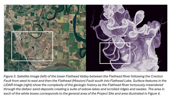
Preferential Flow Pathways of the late Pleistocene Flathead Delta - The shallow aquifer of the south Flathead Valley, beginning at the break in river slope near the city of Kalispell and extending across the valley to the contemporary north shore of Flathead Lake, is also hydraulically connected to Flathead River, Flathead Lake, and groundwaters originating in the Salish Range bordering the west side of the valley (Konizenski, Brietkrietz, & McMutrey, 1968). Although the shallow aquifer of the deltaic deposits are less well understood than the alluvial cobble and gravel dominated deposits in the north valley, the deltaic sand deposits and the shallow aquifer of the south valley have been defined as a “deltaic sand aquifer dominated by medium grain sand and silt deposits” (Noble & Stanford, 1986); (Montana Department of Environmental Quality, 2024). The highly complex lattice of alluvially-sorted sands are oriented in arching suites of paleo-channel features expressed at the surface as scrolled ridges and swales. These surface features are strongly coupled to subsurface point bars and sorted-sediment river channels forming preferential flow pathways (Lorang & Hauer, 2017); (Hauer, Lorang, & Gonser, 2022) and are commonly associated with snowmelt dominated hydrographic regimes, as occur in the Flathead River above Flathead Lake (Figure 4) and elsewhere in the northern Rocky Mountains (Rood, et al., 2024).
Lakeside County Water & Sewer District (LCWSD) Project Site - The Project Site for the proposed MGWPCS Permit No. MTX000307 is located between Ashley Creek, Wiley’s Slough, and several ponds in the immediate project area labeled Pond 4 and Pond 7 (Figure 5). Based on the previous studies of the Flathead deltaic geology and hydrogeology (Noble & Stanford, 1986), (Rose, 2018), the site is characterized by a shallow deltaic sands layer. The Permit Application data reports a median depth-to-water of 4.9 meters (~16 ft) with a median depth to the confining clay/silt/sand layer of 8 meters (~30 ft). Thus, the average wetted depth of the shallow aquifer is approximately 4.5 meters (~15 ft). This shallow aquifer is influenced greatly by seasonal fluctuations in discharge occurring in the Flathead River and the rise in lake level in Flathead Lake (Noble & Stanford, 1986); (Rose, 2018). The Project Site is e ectively within the hydro-geology complex of the Flathead River/Lake f loodplain a ecting both water height and flow direction due to interaction with surface waters, which is also presented in the Montana Ground Water Pollution Control System (MGWPCS) Domestic Wastewater Treatment and Rapid Infiltration System to service the Lakeside County Water & Sewer District (LCWSD), permit #MTX000307 (Montana Department of Environmental Quality, 2024).
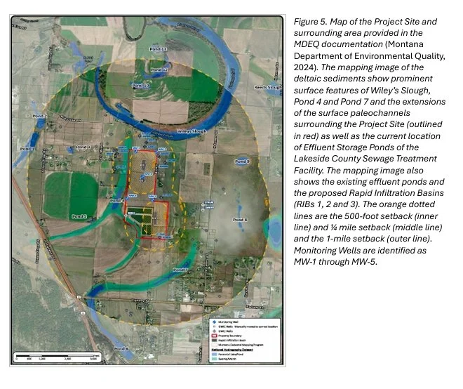
The MGWPCS documentation presents modeled hydrogeological processes for a homogeneous shallow aquifer based on averages and median values of the slug tests distributed among the 5 monitoring wells (see Figure 5). However, based on extensive research elsewhere in the Flathead (Lorang & Hauer, 2017); (Hauer, Lorang, & Gonser, 2022) and elsewhere in western Montana (Rood, et al., 2024), and following analysis of the Satellite and LIDAR Imagery of the Project Site, we conclude that it is extremely unlikely that the shallow aquifer of the Project Site and surrounding area has homogeneous sand deposits. Rather, it is extremely likely that the deltaic sand deposits of the shallow aquifer are characterized by very heterogeneous sedimentology and a complex lattice work of high transmissivity preferential flow pathways. Indeed, the sparse data presented in the MDEQ report; high hydraulic conductivity variation between Monitoring Well 1 (average K equals 7.1 ft/day and Monitoring Well 2 (average K equals 392.4 ft/day) (Montana Department of Environmental Quality, 2024) supports our contention of preferential flow pathways and highly heterogeneous anisotropic properties in the described shallow aquifer. The heterogeneous shallow sand deposits and high range in variation in hydraulic transmissivity is common in alluvial aquifers as rates depend upon material and formation (Woessner W. W., 2017); (Woessner & Poeter, 2024).
Nutrients in Freshwater Ecosystems
Nitrogen Fixation - Nitrogen is one of the primary nutrients critical for the growth and survival of all living organisms. It is a necessary component of many organic molecules including DNA, proteins, and Chlorophyll. Although nitrogen is very abundant in the atmosphere as dinitrogen gas (N2), it is comparatively inaccessible to living organisms. Indeed, N2 gas is a very stable compound due to the strength of the triple bond between the nitrogen atoms. For atmospheric nitrogen gas to be available to make proteins, DNA, and other biologically important compounds, it must first be “broken” and then converted into a di erent and usable form. This is accomplished in the environment by microbial organisms capable of converting dinitrogen gas into ammonia (NH3); a process referred to as Nitrogen Fixation (see Figure 6). Although most nitrogen fixation is carried out by microbial prokaryotes (i.e., very primitive life forms without a DNA cell nucleus) nitrogen can also be f ixed abiotically by lightning or industrial processes. While several higher plant species have symbiotic relationships with nitrogen fixing bacteria, such as legumes and alder, most modern agriculture use industrially based nitrogen fixation, produced as fertilizer. The process of making synthetic fertilizers for use in agriculture by causing N2 to react with H2, known as the Haber-Bosch process, has increased significantly over the past several decades.
Nitrification - Nitrification is the process that converts ammonia (NH3) to nitrite (NO2-) and then to nitrate (NO3-). Most nitrification occurs aerobically and is exclusively done by a di erent suite of microbial prokaryotes than the microbes involved in nitrogen fixation. There are two distinct steps of nitrification. The first step is the oxidation of ammonia to nitrite (NO2-), which is carried out by microbes known as ammonia-oxidizers. The second step in nitrification is the oxidation of nitrite (NO2-) to nitrate (NO3-). This step is carried out by a separate group of microbes known as nitrite-oxidizing bacteria. For complete nitrification, both ammonia oxidation and nitrite oxidation must occur (Figure 6).
Denitrification - Denitrification is the process that converts nitrate (NO3-) to nitrogen gas (N2), thus removing bioavailable nitrogen and returning it to the atmosphere. Unlike nitrification, denitrification is an anaerobic process, occurring mostly in soil and sediments and anoxic zones in lakes and oceans. Similar to nitrogen fixation, denitrification is carried out by a diverse group of microbes (i.e., again primarily prokaryotes), but there is recent evidence that some single-cell eukaryotes are also capable of denitrification (Risgaard Petersen, et al., 2006). Denitrifiers are chemo-organotrophs and thus must also be supplied with some form of organic carbon (e.g., carbohydrates, proteins, sugars, lipids). Denitrification becomes highly limited if/when organic matter that “feeds” the microbes is insu icient to provide the energy to drive the denitrification process.
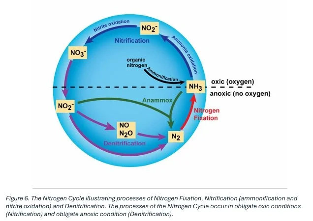
Denitrification is important in that it removes nitrate from the ecosystem and returns it to the atmosphere (N2 gas). This is particularly important in wastewater treatment and the removal of unwanted nitrates from the wastewater effluent. This is critical to both human health and to the environment. Denitrification reduces the chances that the water discharged from a treatment plant will cause undesirable groundwater or surface water contamination or unhealthy NO3 concentrations to subsurface aquifers (e.g., polluting drinking water) or surface waters (e.g., fostering algal blooms).
General Ecological Implications of the Nitrogen Cycle - Many human activities have a significant impact on the nitrogen cycle. Burning fossil fuels, application of nitrogen-based fertilizers, discharge from wastewater treatment, and other activities can dramatically increase the amount of biologically available nitrogen in an ecosystem. Because nitrogen availability often limits the primary productivity of many ecosystems, large changes in the availability of nitrogen often leads to severe alterations of the nitrogen cycle in both aquatic and terrestrial ecosystems.
In freshwater ecosystems (i.e., rivers, wetlands, lakes and nearshore lacustrine systems), increases in nitrogen can lead to harmful algal blooms (HAB) (Howarth, 2008) which then leads to hypoxia (i.e., low oxygen) and even anoxia (i.e., no oxygen) of the waters altering biodiversity, forcing changes in food-web structure, and impacting general habitat leading to broad aquatic system degradation. The addition of bio-available nitrogen into freshwaters can also lead to changes in biodiversity and species composition in algae, invertebrates and fish communities (Hauer, Stanford, & Lorang, 2007). Such changes in turn lead to changes in overall ecosystem integrity (see Federal Clean Water Act (33 U.S.C. §1251 et seq. 1972). More recently, studies have suggested that nitrate pollution may lead to an increased risk of parasitic and infectious diseases among fish and wildlife (Johnson, et al., 2010).
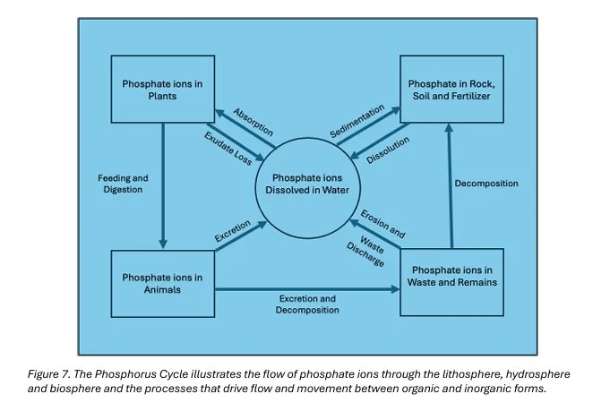
Phosphorus Cycle - The phosphorus cycle is the biogeochemical cycle that involves the movement of phosphorus through the lithosphere, hydrosphere, and biosphere (Figure 7). Unlike the nitrogen cycle, the atmosphere does not play a significant role in the movement of phosphorus because phosphorus and phosphorus-based materials do not readily enter a gaseous phase. Living organisms require phosphorus, a central element of DNA, RNA, and the cellular energy transfer of ADP/ATP. Phosphorus is also a central element in the composition of phospholipids present in cell membranes.
In the lithosphere, phosphorus is an element in long-term storage in rock formations which give up phosphorus to overlying soils. Humans mine phosphorus from rock formations and redistribute phosphorus as apatite for purposes of increasing plant growth and production in agriculture. Plants assimilate phosphorus through absorption of phosphate across cell membranes. To do this the phosphate ions must be dissolved in water. The cells actively “pull” the phosphate ions across their cell membranes into the cell structure of the plant and incorporate it into cellular growth. Phosphate is lost by plants through extra-cellular exudates as part of cell membrane “leakage.” Animals acquire phosphorus through the consumption (i.e., feeding and digestion) of plant material or through other animal sources of a complex food-web. Phosphorus ions leave the animal component of the phosphorus cycle through excretion and decomposition. Plant and animal contributions through waste products and remains lead to phosphate ion movement dissolved into water as water flows through interstitial space in soils or flowing into running water or lacustrine ecosystems.
General Ecological Implications of the Phosphorus Cycle - On land, phosphorus gradually becomes less available to plants over thousands of years since it is slowly lost in runo . Many natural systems tightly cycle phosphorus (i.e., very slow leakage from the watershed); however, as disturbances increase due to natural or human activity, phosphorus becomes increasingly mobile to local recycling and is “lost” from the watershed as phosphorus enters streams and is displaced downslope.
Low concentration of phosphorus in freshwater systems reduces plant growth and slows microbial growth. Microorganisms, particularly freshwater algae, act as both sinks and sources of available phosphorus in the biogeochemical cycle. In freshwater systems phosphorus is often a limiting nutrient. In other words, concentrations are often very low and limit growth of primary producers. Indeed, freshwater algae, as well as emergent and floating plants, are extremely efficient in taking up and sequestering phosphorus leading to over-production and eutrophication of freshwater systems when phosphorus concentrations increase due to disturbances or human caused pollution, such as wastewater outfall.
Ecological Risk and Uncertainties
The Montana Department of Environmental Quality (MDEQ) recently completed its Environmental Assessment and issued a draft permit #MTX000307 requesting public comment. In this section of our expert opinion findings of fact and judgment, we focus on the ecological risks and uncertainties associated with the Project Site geology and sedimentology, the discharge of wastewater into Rapid Infiltration Basins that leach water pathogens, nitrogen, and phosphorus into the underlying shallow deltaic sands aquifer and we provide analysis of potential for significant ecological impacts to surface waters leading to further impairment in the Ashley Creek area and impact to the physical, chemical and biological integrity of the Flathead River/Lake ecosystem (see Federal Clean Water Act 33 U.S.C. §1251 et seq. 1972).
Nutrient Transport and Fate - The permitting fact sheet for MGWPCS Permit No. MTX000307 states nitrogen concentration levels from the Current Wastewater System with Effluent Holding Ponds will be reduced from current levels of approximately 30 mg/L as NO3 to approximately 8 mg/L. This is to be done through denitrification processes in the “secondary treatment process.” Thus, the MDEQ documents conclude that the wastewater effluent at 8 mg/L would enter the RIBs and infiltrate into the ground and mix with the existing groundwater. This reduction in nitrate from 30 mg/L to 8 mg/L would represent about an 80% reduction from current Lakeside Sewer district disposal from the pond-system that receives surface application on the field to the west of the proposed Project.
While a concentration of 8 mg/L NO3- does not exceed the DEQs standards for human health (i.e., 10 mg/L as NO3-) described in Table 6 of the document from the DEQ-7 Montana Numeric Water Quality Standards (Montana Department of Environmental Quality, 2019), it does far exceed the total nitrogen concentration 0.11 mg/L of the receiving groundwater sampled from Monitoring Well 5 described in Table 4 of the DEQ fact sheet document (Montana Department of Environmental Quality, 2024).
The data summarized here; however, from the fact sheet for MGWPCS Permit No. MTX000307 is dependent on the likely wrong conclusion that the Project Site is composed of a homogeneous sand deposit, which it almost certainly is not, and that the models used to calculate the rate at which wastewater will move off the site and into surface waters, is thus also erroneous. Should wastewater seepage from the RIB infiltration system escape the shallow aquifer mixing zones and reach surface waters at or near the 8 mg/L concentration this would far exceed the Numeric Nutrient Standards for Wadeable Streams in Montana Ecoregion 15, the Northern Rockies, which is set at 0.275 mg/L (Suplee & Watson, 2013).
The assumptions made by MDEQ regarding denitrification in the shallow aquafer are likely significantly overestimated. As pointed out above, denitrification is an energy intensive, anaerobic process conducted by microbes requiring organic matter (i.e., microbial chemo organotrophs). The effluent waters leaching from the RIBs will purposefully be depleted of organic matter (i.e., via BOD reduction) and will carry oxygen into the aquifer. These factors reduce the capacity for denitrification. Indeed, Kolbe et al. (2019) found pronounced decreases of denitrification reactivity in near groundwater table surface waters suggesting that estimates of denitrification used broadly have underestimated the capacity of deep aquifers to remove nitrate, while overestimating nitrate removal in shallow flow paths. Even if we use the permit findings made by MDEQ, the aquifer’s characteristics mean that the highly concentrated nitrate-nitrogen wastes that are rapidly infiltrated into the surface groundwater will be discharged to downgradient groundwaters and surface waters with little mixing as waters flow out from the mounded RIBs and without denitrification.
The fate and transport of nitrate is further complicated by the high likelihood of preferential flow pathways, described in detail in the sections above. While it is likely that as wastewater leaves the RIBs there is a hydrogeological propensity to distribute evenly in all directions, this is not the case in heterogeneous deposits, especially where alluvially sorted deposits in the subsurface foster high transmissivity. Evidence of heterogeneity in the alluvial deltaic sand deposits is most directly seen in Monitoring Well data presented in the fact sheet for MGWPCS Permit No. MTX000307. These data show that especially in the NE quadrant of the Project Site the well logs strongly suggest the well was likely placed in a preferential flow pathway with transmissivity rates observed ~ 500 ft/day. The Satellite and LIDAR Imagery data (see Figure 3), further corroborate the well data and strongly suggest that wastewater could travel rapidly, on the order of a few days, to Wiley’s Slough, which has direct surface connection to Ashely Creek and Flathead River. Although the highest transmissivity rates observed were recorded at ~ 500 ft/day, there is at least a reasonable probability that there are preferential flow pathways within the Project Site with even higher flow rates.
These data largely nullify the MGWPCS Permit No. MTX000307 assumptions about wastewater transit time through the Project Site deltaic sediment aquifer to nearby surface waters, the extent of pollutant dilution in the identified mixing zones, the assumed denitrification transformation while waters are in transport away from the Project Site, as well as assumptions about the timing and concentration of nitrate loading to surface waters, (including Wiley’s Slough, and the wetland identified as Pond 4).
Regarding phosphorus, the proposed sewer treatment plant is projected to remove an estimated 70% of the phosphorus load to be discharged from the proposed upgraded Sewage Treatment Facility. The Montana DEQ Fact Sheet document estimates a projected bio-available phosphorus concentration of 1.5 mg/L at the point of entry into the wastewater distribution system of the RIBs. The existing lagoon system has an estimated effluent concentration of bio-available phosphorus of 8 mg/L. The 1.5 mg/L concentration represents a significant reduction in PO4; however, the 200,000 gpd addition to the current lagoon system effluent represents a significant “load” to the receiving shallow groundwater of the facility.
While the decrease in concentration of phosphorus and the increase in the volume of wastewater effluent results in approximately the same PO4 lbs./day (or Kg/day), the direct injection of bio-available phosphorus via the RIBs, similar to nitrate nitrogen, results in an elevated risk of phosphorus breakthrough into the nearby surface waters including Wiley’s Slough, Pond 4, and other nearby surface waterways. The MGWPCS Permit No. MTX000307 assumptions that phosphorus contributions to the aquifer will be mitigated by the long time-period for transit to surface waters, like that of nitrate, are likely false. While clay soils are known to bond to phosphorus, sandy soils, such as those found in the deltaic sands of the shallow aquifer, generally don’t share this same property (Muindi, 2019).
Like the case for nitrogen, should wastewater seepage from the RIBs infiltration system escape the shallow aquifer mixing zones, which we have shown to be highly likely, the increased loading of bio-available PO4 runs a high risk of entering near project surface waters largely unmodified and unattenuated from the point of wastewater discharge into the RIBs.
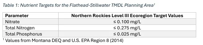
Flathead-Stillwater TMDL Attainability Analysis – EPA defines a Total Maximum Daily Load (TMDL) as the calculation of the maximum amount of a pollutant allowed to enter a waterbody so that the waterbody will meet and continue to meet water quality standards for that particular pollutant. A TMDL determines a pollutant reduction target and allocates load reductions necessary to the source(s) of the pollutant. The surface waters at greatest risk are Wiley’s Slough and Pond 4, (which is actually a wetland derived as an oxbow paleo channel with direct surface connection to Wiley’s Slough). Wiley’s Slough, in turn, has a direct surface water connection to Ashley Creek and the Flathead River. Nutrient target criteria for the Lower Ashley Creek drainage (MT76O002_030) are consistent with those found throughout the Northern Rockies ecoregion (see Table 1) from the Numeric Nutrient Criteria for Montana’s Wadable Steams and Rivers. These targets are established in the Flathead-Stillwater Planning Area Nutrient, Sediment, and Temperature TMDLs and Water Quality Improvement Plan (2014).
Using data collected over the preceding decade, Department of Environmental Quality (DEQ) determined that four waterbody segments in the Ashley Creek watershed (one tributary and three Ashley Creek segments) currently do not meet the nutrient water quality standards ( Montana DEQ; U.S. EPA Region 8, 2014). Lower Ashley Creek (MT760002-030) was specifically identified with “Nutrient Probable Causes on the 2014 303(d) List.” Thus, the basic assumptions underpinning the Load Allocations for the Flathead Stillwater TMDLs specific to Lower Ashley Creek, MT760002_030, the hydrological surface water unit to which Wiley’s Slough and most surface water in the project proximity have already exceed the target values with average nitrate (NO3) values at 2.06 mg/L, average total nitrogen (TN) 3.14 mg/L, and total phosphorus (TP) 0.059 mg/L (from Table 5-7 ( Montana DEQ; U.S. EPA Region 8, 2014)). These values were based on mean sample values from 2003-2008 and used in the TMDL reference documentation. MDEQ documentation agrees that Ashley Creek segments currently exceed target values. They further state that the target values are established at levels to protect aquatic life and recreation.
It is important to recognize the scientific conclusion, and EPA-approved determination, that Lower Ashley Creek is impaired and still on the State’s 303(d) List for impairments related to exceedances in Nitrate Nitrogen, Total Nitrogen and Total Phosphorus concentrations as well as Chlorophyll-a, which is a bio-indicator of nutrient enrichment. One can therefore only conclude that Lower Ashley Creek has no remaining assimilative capacity for any new additions of those pollutants without first nutrient reduction in those receiving waters.
In this regard, due to special permits for the Kalispell WWTP Waste Load Allocation, “no wastes may be discharged such that the wastes, either alone or in combination with other wastes, will violate, or can reasonably be expected to violate, any of the standards”. This permitted action allows for higher TN and TP in Lower Ashley Creek; however, the permit also has benchmark goals of 0.41 and 2.00 mg/L for TP and TN, respectively. Furthermore, the waste load allocation permitting requirements identify reduction values of 30% for TN and 44% for TP concentrations within the system. With nutrient loads that already exceed TMDL water quality standards and previously permitted point sources for further nutrient loads where the permits are dependent upon net load reductions, the proposed MGWPCS Permit No. MTX000307 – LCWSD Rapid Infiltration System as currently designed and proposed represent a clear risk for a new point source of TN and TP that will further exceed target values.
As stated above, the sedimentology and alluvial history of the Project Site has a high likelihood of nutrient attenuation failure with wastewater discharges moving far more rapidly into the nearby surface waters than modeled in the proposal. These pollutants, whether entering Pond/wetland 4 with direct surface water connection to Wiley’s Slough or entering directly into the Slough, have in turn a direct nexus to Lower Ashley Creek. Also, as explained above regarding likely nutrient concentrations and loads, no meaningful attenuation or dilution is likely before discharging to surface water. The added septage wastewater presents as a new pollutant addition and is likely to cause or contribute to exceedances of numeric nutrient criteria, as well as exceed algal growth parameters and cause other related impairments. The proposed LCWSD discharge would - by itself - exceed the TMDL targets in surface water upon breakthrough, even if it takes over a year (as the Project Proposal model assumes) and certainly if preferential pathways to surface water exist (as per earlier opinion).
Ecological Implications – The implications of risk and uncertainties for the proposed MGWPCS Permit No. MTX000307 – LCWSD Rapid Infiltration System are highly significant. While MDEQ concluded that there would be no significant adverse impacts associated with the Proposed Project, we find that the assumptions regarding the geology and sedimentology of the Project Site, as well as nutrients from the project mixing and being attenuated on site, are very likely over optimistic at best, and if incorrect would result in significant adverse impacts.
The “Flathead-Stillwater TMDL Attainability Analysis,” provide the underpinning Load Allocations for the Flathead Stillwater TMDLs specific to Lower Ashley Creek, MT760002_030, the hydrological surface water within the unit to which Wiley’s Slough and most surface water in the project proximity has hydrologic connectivity. It is critically important to recognize the TMDL scientific conclusion, and EPA-approved determination, that Lower Ashley Creek is impaired and remains on the State’s 303(d) List for impairments related to Total Nitrogen and Total Phosphorus exceedances, and thus no assimilative capacity remains for any additions of nitrogen or phosphorus pollutants, which directly affect algal production, as well as Chlorophyll-a concentration and O2 flux.
The MGWPCS Permit No. MTX000307 recognizes that the delta aquifer of the site is hydrologically connected to surface waters with many surface waters within a one-mile radius of the facility (i.e., Wiley’s Slough ¼ mile to the north from the property boundary, Pond/Wetland 4 immediately to the west of the proposed RIBs within the property boundary, and Pond/Wetland 7 a ½ mile southeast of RIB-3)(see Figure 5). As discussed above, the assumptions regarding the mixing and movement of wastewater from the Project Site and radiating away from the RIBs are erroneously assuming a homogeneous sand deposit. However, MGWPCS Permit No. MTX000307 has failed to recognize that the Project Site, indeed the entire area around the project in the southwestern ¼ of the Flathead Valley, is highly heterogeneous. While the contemporary Flathead River channel is 2.3 miles north of the Project Site flowing west to east and then 3.7 miles to the eastern side of the valley and then flowing south into Flathead Lake, the early Holocene Flathead River affected the site through cut-and-fill alluviation creating an extremely heterogeneous array a sediments with linear deposits filled with paleochannels on the surface and in the subsurface.
The MGWPCS Permit No. MTX000307 recognizes that the water table at the Project Site has a small gradient under current conditions; however, the water table will experience mounding because of the wastewater pushing effluent out radially in all directions. Due to the evidence of heterogeneity in the subsurface conditions, it is unlikely that the homogeneous models which describe this mounding effect in the permit are representative of true conditions. The five test wells, MW 1-5, show evidence of this subsurface hydraulic conductivity heterogeneity; however, they do not adequately characterize the current conditions. Additional test wells would be necessary to truly model the shallow aquifer conditions.
Wiley’s Slough is “surface connected” to lower Ashley Creek. Ashley Creek was found to be impaired for aquatic life and primary contact recreation (2020 303(d) list). The waters of the Flathead River, as well as waters from the upper Stillwater and Whitefish Rivers, typically have concentrations of nitrate nitrogen (NO3-) less than 150 µg/L (0.15 mg/L) and bio-available phosphorus (PO4) less than 10 µg/L (0.01 mg/L). Indeed, the lower Flathead River near Flathead Lake and waters in Flathead Lake have a typical annual mean nitrate concentration around 40 µg/L (0.04 mg/L) and bio-available phosphorus closer to 5 µg/L (0.005 mg/L). Flathead Lake TMDL targets were largely based on the work done at Flathead Lake Biological Station (Stanford, Ellis, Craft, & Poole, 1997). A 15% reduction in man caused nitrogen and phosphorus loads, plus a 10 percent margin of safety was proposed as the TMDL.
These wastewater effluents, that would pass through the preferential flow pathways of the shallow aquafer of the Project Site into surface waters represents approximately a 600% increase to the published background nitrate and phosphorus concentrations of Ashley Creek, at the Kalispell airport road to the mouth of the Flathead River ( Montana DEQ; U.S. EPA Region 8, 2014) and a nearly 1000 times increase over the Flathead River/Lake receiving surface waters. Furthermore, these nutrient concentrations significantly exceed the Montana Numeric Water Quality Standards listed in the Circular DEQ-7 water quality standards (Montana Department of Environmental Quality, 2019).
Eutrophication is a leading cause of freshwater impairment of many river and lake ecosystems in the world. Eutrophication is characterized by excessive plant and algal growth due to the increased availability of one or more limiting growth factors especially the nutrients, nitrogen and phosphorus. Algal blooms are strongly linked to nutrient enrichment resulting from anthropogenic activities such as agriculture, industry, and sewage disposal. The most conspicuous effect of eutrophication is the creation of dense blooms of noxious, foul-smelling phytoplankton that reduce water clarity and harm water quality. When dense algal blooms eventually die, microbial decomposition can severely deplete dissolved oxygen, creating hypoxic or anoxic ‘dead zones' in water bodies like Wiley’s Slough, and the pond/wetland systems near the Project Site.
Based on the MGWPCS Permit No. MTX000307 data provided, we estimate that with a wastewater effluent of 200,000 gpd (i.e., ~757,000 liters per day or 276M liters per year), then approximately 414 kg/yr (~910 lbs./yr) of phosphorus and 2,070 kg/yr (~4554 lbs./yr) of nitrate would enter the project area shallow sediment layer and shallow groundwater system. In light of the mounding of wastewater on the project site and the high potential for direct surface water connection to Wiley’s Slough and Ashley Creek and then to the Flathead River, this level of loading of N and P would almost certainly result in significant increase in algal blooms (including Lemna sp. [duckweed]) that would directly affect the freshwater ecosystem water quality and ecological integrity of the Flathead River/Lake Ecosystem.
While this estimate has been argued is an overall decrease in net TN and TP for the Flathead River/Lake Basin as distributed septage from Flathead County is proposed to be treated and have nutrient reduction at the sewer treatment plant. The permit proposal does not address the risks involved with concentrating effluent at a previously identified location of impact, the Lower Ashley Creek basin, Stillwater-Flathead River Water Quality Improvement Plan of 2014 ( Montana DEQ; U.S. EPA Region 8, 2014).
As identified above, the risks of eutrophication to the surface waters in the immediate area represent environmental threats not identified by the current permit, and likely are in violation of current TMDL permits for Lower Ashley Creek. Indeed, the eutrophication of Ashley Creek, Flathead River and Flathead Lake due to increased nutrient loading will be exacerbated and will contribute to continued nutrient exceedances for those pollutants of concern ( Montana DEQ; U.S. EPA Region 8, 2014) with continued non-attainment of designated uses (i.e., aquatic life, propagation of salmonids and cold-water fisheries, recreational use) for the receiving surface water.
These surface waters that include Wiley’s Slough with direct surface nexus to Lower Ashley Creek is at high risk of impact to the surrounding bodies of water especially Lower Ashley Creek, the Flathead River, and potentially extending as far as Flathead Lake. Further effects of eutrophication, described above, would likely impact both the safety of aquatic life as well as the recreational opportunities for Montanans. Health implications could extend to livestock as the toxic effects related to eutrophication are well documented (e.g., Heisler, et al., 2008; Akinnawo, 2023). Toxicity from harmful algal blooms, referred to as HAB in most literature, has been demonstrated to have spacial and temporal impacts on downgradient waters (Oliver, Dahlgren, & Deas, 2014).
Thus, the eutrophication of Ashley Creek, Flathead River and Flathead Lake due to increased nutrient loading will be exacerbated and will contribute to continued nutrient exceedances for those pollutants of concern ( Montana DEQ; U.S. EPA Region 8, 2014) with continued non-attainment of designated uses (i.e., aquatic life, propagation of salmonids and cold-water fisheries, recreational use) for the receiving surface water.
Summary Opinion/Review of Proposed Project
Montana DEQ Permit application documentation presents the Project Site as a homogeneous shallow sand layer. However, the Project Site is composed of deltaic sands subjected to cut-and-fill alluvial processes creating heterogeneous paleochannels, oxbows, and suites of ridge-and-swale surface and subsurface deposits.
Montana DEQ Permit monitoring well data supports our opinion that the LCWSD Rapid Infiltration Basins (RIBs) are sited over a highly heterogenous sand layer with linear preferential flow ways. Demonstrated hydraulic conductivity rates ranged from about 7 to 500 ft/day, depending on monitoring well location.
It is our professional opinion that there is clear evidence (e.g., previous studies, satellite imagery, LIDAR imagery) that the receiving delta aquifer of the Project Site is highly heterogeneous and may have many preferential flow pathways. Thus, the receiving delta aquifer is poorly suited for nutrient pollutant assimilation, especially phosphorus or nitrogenous pollutants. Our conclusions here agree with the report findings of HydroSolutions Inc. that the wastewaters may appear within weeks and perhaps even days in surrounding surface waters rather than the Montana DEQ Permit application estimated time frame of years to decades.
Nitrogen and Phosphorus are often limiting nutrients in freshwater ecosystems. When these elements are “loaded” into freshwaters, the increased concentrations lead to increased productivity of the photosynthetic-base of the food-web. In surface freshwaters, the increased productivity leads to loss of water clarity and increased rates of eutrophication, degraded (impaired) freshwater ecosystems, losses of biodiversity, increased blooms of noxious algae, simplification of the algal community, losses of plankton and invertebrate community structure, losses of preferred fish species, expansion of undesirable fish species, and losses of recreational opportunities.
Nutrient fate and transport are critical to the suitability of the proposed project. The Montana DEQ Permit application clearly acknowledges the Project Site is surrounded by interconnected surface waters. It is our opinion, based on our understanding of the effects of N and P in freshwater ecosystems and the rates of water flow through preferential flow pathways so prevalent in the Project Site, that the project as currently designed using the local shallow aquafer for direct infiltration of estimated 200,000 gpd of wastewater, presents an unacceptably high risk that highly concentrated nutrient wastes will be discharged to surface waters.
We further believe that the Montana DEQ Permit application is extremely optimistic about wastewater nutrient attenuation. Aquifer conditions strongly suggest that any dilution, attenuation, or chemical change to nitrate nitrogen or phosphorus is highly unlikely. The nutrient fate and transport condition becomes untenable considering the high likelihood of preferential pathways dominating the site and thus nullify the Montana DEQ Permit application assumptions about (a) transit time, (b) extent of pollutant dilution, (c) assumed chemical transformation, and (d) assumption about concentration and load of wastewater pollutants reaching interconnected surface waters.
Montana DEQ Permit application asserts that because the wastewater discharge permit is related to gathering diffuse septage from across Flathead County and treating the waste to a higher standard of care, that discharge at the proposed location is nonsignificant because the discharge allegedly represents a “net loss” of nutrient pollutants to Flathead Lake under the Flathead Lake TMDL. This argument collapses if the RIBs and the groundwater infiltrated wastewater system does not perform as proposed. For reasons given above, we believe that there is an exceptionally high probability that the receiving sand aquifer will not perform as proposed. Further, data presented in the Montana DEQ Permit application supports our asserted high level of risk and uncertainty.
Regarding the ecological impact of probable project failure, it is our opinion that the proposed discharges and consequent nutrient loading on the interconnected surface waters surrounding the Project Site, including nexus with the Flathead River surface waters, the addition of a new municipal-scale wastewater discharge within the shallow Flathead Delta to nearby Lower Ashley Creek creates a significant likelihood of causing or contributing to negative ecological effects in receiving surface waters, including but not limited to eutrophication in Lower Ashley Creek, Flathead River, and Flathead Lake.
References
Montana DEQ; U.S. EPA Region 8. (2014). Flathead – Stillwater Planning Area Nutrient, Sediment, and Temperature TMDLs and Water Quality Improvement Plan. Helena: Montana Dept. of Environmental Quality.
Akinnawo, S. O. (2023). Eutrophication: Causes, consequences, physical, chemical and biological techniques for mitigation strategies. Environmetal Challenges, 12. doi:https://doi.org/10.1016/j.envc.2023.100733
Federal Clean Water Act (33 U.S.C. §§ 1251 et seq.). (1972).
Hauer, F. R., Lorang, M. L., & Gonser, T. (2022). Remote Sensing to Characterize River Floodplain Structure and Function. Remote Sensing, 14(5), 1132.
Hauer, F. R., Stanford, J. A., Lorang, M. S., Ellis, B. K., & Craft, J. A. (2007). Sustaining Rocky Mountain Landscapes: Science, Policy and Management of the Crown of the Continent Ecosystem. Aquatic Ecosystem Health, 117-134.
Hauer, F., & Stanford, J. (1982). Ecology and Life Histories of Three Net-Spinning Caddisfly Species (Hydropsychidae:Hydropsyche) in the Flathead River, Montana. Freshwater Invertebrate Biology, 1(4), 18-29. doi:10.2307/1467138
Hauer, F., Stanford, J., & Lorang, M. (2007). Pattern and Process in Northern Rocky Mountain Headwaters: Ecological Linkages in the Headwaters of the Crown of the Continent. Journal of the American Water Resources Association, 43(1), 104-117.
Heisler, J., Gilber, P., Burkholder, J., Anderson, D., Cochlan, W., Dennison, W., . . . Suddleson, M. (2008). Eutrophication and Harmful Algal Blooms: A Scientific Consensus. Harmful Algae. PubMed Central, 8(1), 3-13. doi:https://doi.org/10.1016/j.hal.2008.08.006
Howarth, R. W. (2008). Coastal nitrogen pollution: A review of sources and trends globally and regionally. Harmful Algae, 8(1), 14-20. doi:10.1016/j.hal.2008.08.015
Johnson, P., Townsend, A., Cleveland, C., Gilbert, P., Howarth, R., McKenzie, V., . . . Ward, M. (2010). Linking environmental nutrient enrichment and disease emergence in humans and wildlife. Ecological Applications, 20, 16-29. doi:10.1890/08-0633.1
Kolbe, T., de Dreuzy, J., Abbott, B., Aquilina, L., Babey, T., Green, C., . . . Pei er, S. (2019). Stratification of reactivity determines nitrate removal in groundwater. Proceedings of the National Academy of Sciences, 116(7), 2494-2499.
Konizenski, R., Brietkrietz, A., & McMutrey, R. (1968). Geology and ground water resources of the Kalispell valley, northwestern Montana: Montana Bureau of Mines and Geology Bulletin. Helena: Montana Bureau of Mines and Geology.